North Borneo Dispute - Analysis on 1878 and 1903 Treaties
Disclaimer
I’ve always been interested in history, and the idea of diving deep into some areas of history up to even conducting our own readings and research on a specific area, and, perhaps, finding something new to public knowledge. I have never done so. But realised that I should do so for where I opportunity to where other’s may not. There are two areas of history for where I’m fortunate to be brought up with basic understanding and background knowledge. One is Karate, and the other is Sulu Sultanate and the North Borneo Dispute.
Regarding to Sulu Sultanate history, the history has been part of a long line of oral history passed down from Sultans to Sultans, Sultans to children, down to my generation in my family. We have also retrieved documentation from the Bruneian Archives allowing us to trace our ancestry all the way back to 1400s.
Regarding the North Borneo Dispute, I carry out my research from an unbiased view. However I do feel obligated to state the biased that I was introduced with. One: is that, as a descendant, I was told that the Sulu Sultanate has some kind of legitimate claim to Sabah; two: as a Malaysian, Sabah is a definite part of Malaysia and that the former may never change that; and three: it is only Sulu Sultanate that has a claim to Sabah and not The Philippines (perhaps a research for another time). My research comes to no firm conclusion apart from mentioning what is generally accepted by historians, what past documents presents, possible interpretations to make sense of the documents, the possible intention of documents, and when they were written, indicating their reliability or lack thereof. No attempts has been made to intentionally draw towards a chosen conclusion.
To describe my neutrality further, I see myself as someone who does not take pride for what he has not accomplished himself. You may be familiar with the term ‘glory seeking’, and may also be familiar with that Malaysians are known to glory-seek. I don’t see myself doing that. If a Malaysian happen to make international headlines for an achievement that gives good name to Malaysia, unless I’ve made some contribution to his or her achievement, I technically can’t take pride for it as it is not my achievement. Instead, I would say that I feel honoured to be a part of what he or she represents, that is being a Malaysian. Similarly, I can’t take pride in my Sulu royal heritage as it is not something I achieved. Instead I will say that I am honoured to be part an interesting and deep history.
North Borneo Dispute - Background
This article is my own further analysis on the North Borneo Dispute. In order to understand the rest of the article, a background understanding on the issue is required. The Wikipedia page provides sufficient basic understanding. Intro from Wikipedia:
The North Borneo dispute, also known as the Sabah dispute, is the territorial dispute between Malaysia and the Philippines over much of the eastern part of the state of Sabah. Sabah was previously known as North Borneo prior to the formation of the Malaysian federation. The Philippines, presenting itself as the successor state of the Sultanate of Sulu, retains a "dormant claim" on Eastern Sabah on the basis that the territory was only leased to the British North Borneo Company in 1878, with the sovereignty of the Sultanate (and subsequently the Republic) over the territory never having been relinquished. However, Malaysia considers this dispute as a "non-issue" as it interprets the 1878 agreement as that of cession, and it deems that the residents of Sabah (including Eastern Sabah) had exercised their right to self-determination when they joined to form the Malaysian federation in 1963.
1878 Agreement
A lot of emphasis is placed on the ambiguous Malay term ‘pajak’ within the 1878 Agreement Signed by Sultan Jamal-ul-Azam of Sulu appointing Baron de Overbeck as Dato Bendahara and Raja Sandakan regarding as a major factor of the dispute for where the British and Malaysia translates it as ‘cease’ whereas the Sulu translates it as ‘lease’ . However the later parts of the agreement reveals more. The term “Menyewakan” (root word “sewa”), which translates to “rent out” or “lease”, is found.
 |
| Image of the 22 January 1878 Agreement Signed by Sultan Jamal-ul-Azam of Sulu appointing Baron de Overbeck as Dato Bendahara and Raja Sandakan with coloured outline showing part of two sentences, one with the word ‘menyewakan’ translating to ‘rent out’, and he other with the words ‘anugerahi’ and ‘serahkan’ translating to ‘to award’ / ‘bestow' and ‘hand over’ / ‘surrender’[1][2]. Full transcript and translation also available a https://zadscavern.blogspot.com/2021/05/transcript-and-translation-to-22.html[2]. |
Jawi (Arabic script based Malay) transcript:
٠”... سرة د اتس سڬال ڤركارا٢ يڠ كيت ڤوڽ دان د اتس حاصيل نڬري٢ ايت دان اد بركواس اكن مڽيواكن تانه٢ ايت دان لاڬي اتس بند٢ يڠدالم تانه دان اتس تومبوه٢هن دان بناتڠ٢ سرة بوله ڤول مڠاداكن حكم٢ دان ممبواة وڠ دان ممبواة دان مناروه سلدادو دان كڤل٢ ڤراڠ دان مڠاداكن چوكي اتس دڬاڠن دالم نڬري ايت دان اتس دڬاڠن لاين٢ بڠسا اسيڠ دان لاين٢ چوكي دان بيا اتس اورڠ٢ نڬري ايت سڤرت يڠ دفيكركنڽ ڤاتت دان هاروس برساما٢ دڠن سكلين كواس يڠ برڤاتوتن يڠ دلاكوكن اوله سكلين راج٢ يڠ ممرينته. مك كيت سده انڬراهي دان سراهكن سمواڽ ايت دڠن سوكا ريضا كيت سنديري مك انيله كيت مڽتاكن كڤد بڠسااسيڠ٢ يڠتله(؟) كيت مڠاداكن ڤرجنجين صحابة برصحابة دڠن ڤرهوبوڠن دان كيت امڤوڽ تيته كڤد سكلين داتؤ٢ دان اورڠبسر٢ دان ڤمرينته٢ دان ڤڬاوي٢ يڠاد(؟) منداڤت كواس درڤد كيت دالم ڤسيسر٢ يڠترسبوة(؟) ايت هندقله اي منريما داتؤ بندهارا ايت سڤرة ڤڠهولو ڤمرنته اتس كراجأن يڠترسبوت(؟) ايت دان منورة ڤرينتهڽ سڤرة كيت سنديري ...“[1][2]٠
Rumi (Romanised Malay) transcript:
“... serta di atas segala perkara2 [perkara-perkara] yang kita punya dan di atas hasil negeri2 [negeri-negeri] itu dan ada berkuasa akan menyewakan tanah2 [tanah-tanah] itu dan lagi atas benda2 [benda-benda] yangdalam(?) tanah dan atas tumbuh2han [tumbuh-tumbuhan] dan binatang2 [binatang-binatang] serta boleh pula mengadakan hukum2 [hukum-hukum] dan membuat wang dan membuat dan menaruh soldadu dan kapal2 [kapal-kapal] perang dan mengadakan cukai atas dagangan dalam negeri itu dan atas dagangan lain2 [lain-lain] bangsa asing dan lain2 [lain-lain] cukai dan biaya(?) atas orang2 [orang-orang] negeri itu seperti yang difikirkannya patut dan harus bersama2 [bersama-sama] dengan sekelian kuasa yang berpatutan yang dilakukan oleh sekelian raja2 [raja-raja] yang memerintah. Maka kita sudah anugerahi dan serahkan semuanya itu dengan suka redha kita sendiri maka inilah kita menyatakan kepada bangsaasing2 [bangsaasing-bangsaasing] yangtelah(?) kita mengadakan perjanjian sahabat bersahabat dengan perhubungan dan kita empunya titah kepada sekelian dato’2 [dato’-dato’] dan orangbesar2 [orangbesar-orangbesar] dan pemerintah2 [pemerintah-pemerintah] dan pegawai2 [pegawai-pegawai] yangada(?) mendapat kuasa daripada kita dalam pesisir2 [pesisir-pesisir] yangtersebut(?) itu hendaklah ia menerima Dato’ Bendahara itu seperti penghulu pemerintah atas kerajaan yangtersebut(?) itu dan menurut perintahnya seperti kita sendiri ...[2]”
English translation:
“... as well as on all the things that we have and on the products of those states and with power will rent out those lands and again on things that is within the land and on plants and animals as well as can also make laws and make money and make and place soldiers and warships and impose taxes on the trade within the state and on the trade of other foreign races and such other taxes and charges on the people of the state as he/she thinks fit and necessary together with all power that is appropriate to exercise by all kings whom are ruling. Hence we have ‘anugerahi’ [award/bestow] and ‘serahkan’ [hand over / surrender] all that with our own pleasured sincerity hence this we state to the foreign races that have we made a treaty of friendship kinship with relationship and we the owners command to all dato’s and important people and rulers and officials that have received power from us within the aforementioned coasts that shall receive Dato’ Bendahara as the chief ruler over the aforementioned government and according to his orders like our own ...[2]”
| Full transcript and translation of the 22 January 1878 Agreement Signed by Sultan Jamal-ul-Azam of Sulu appointing Baron de Overbeck as Dato Bendahara and Raja Sandakan.[2] |
Unlike with the case of ‘pajak’, ‘menyewakan’ and its root word, ‘sewa’, are non-ambiguous and cannot be misunderstood to mean anything else apart from “rent out” and “rent” respectively in the Malay language. The word for “sell” in the Malay would be “jual”, or “menjualkan” if it were to replace the word ‘menyewakan’ for correct grammatical use. These too are non-ambiguous and cannot be misunderstood to mean anything else other than “sell”. However, “jual” nor “menjualkan” are not to be found in the document. Further down in the document, the words “anugerahi” and “serahkan” are found.
“Anugerahi” (root word “anugerah”) translates to “to award”, whereas “serahkan” (root word “serah”) translate to “surrender”, “give up” or “hand over”. “Serah” as well as “serahkan” can be used in many ways in the Malay language just as its English counterpart, “surrender”, can be in English. Some critics aruge to say that the use of “menyewakan” (rent out) followed by “anugerahi dan serahkan” (award and surrender) in a the document presents inconsistency regarding its intent, and hence implies that menyewakan” (rent out) should be superceded by the latter[3]. This argument is used conclude the document as a cessation agreement. However, this argument only works if “anugerahi” and “serahkan” is assumed to be non-ambiguous where “anugerahi” is implied to mean “to gift” instead or “to award”, and where “serahkan” is implied to mean nothing other than “to give” instead of other possibilities.
The issue with the translation of the terms “cease” and “cessation” is that the literal meaning is “to discontinue” and “discontinuation” while implying a purchase. The direct translation for these terms into Malay are “berhenti” or “pemberhentian”, and doesn’t imply a purchase or sales. “Purchase” and “sales” would be “pembelian” (root word “beli”, meaning “to buy”) and “jualan” (root word “jual”, meaning “to sell”) in Malay. These words are not found in the documentation. In Malay, “to gift” would be “menghadiahkan” (root word “hadiah”), whereas “to give” would be “memberi” or “membagi” (root words “beri” and “bagi” respectively). However, to use the Malay terms for “gift” or “give” for either rental or purchase context would be incorrect since a payment is expected in return, just as it would also be incorrect in English. Hence, why they aren't used in the document but instead “to award”, or “anugerahi” in Malay, is used. This also adds a sense of honour to their foreign guests. The term “serahkan” could possibly refer to the hand over process as opposed to surrender.
“Serah” can be used in a number of ways. For example, “saya meneyerah kalah” translates to “I admit defeat”, where “kalah” translates to “defeat” or “lose (in a fight or battle)”, similar to how “surrender” can be used in English. “Serahan” directly translate to the act of “surrender”. “Saya serahkan kepada kamu” translates to “I leave it up to you to” or “I hand it over to you” regarding a decision, right or possession. The same is the case for “surrender” in English. In a purchase or rental agreement, apart from the payment amount and to whom, it would be natural to also include an agreement of the handover process, e.g. date, time and location. The term for the “hand over” in Malay would be “serah” or “serahkan” as “to hand over”. Just as “hand over” is in English, “serah” in Malay too does not indicate neither purchase nor rental but merely represents to process of a property being passed from one hand to another.
Since the non-ambiguous term “menyewakan” to mean “rent out” or “rent” was specifically used, followed by “serahkan”, it would not be insensible to interpret the document as expressing the intent of the Sulu Sultan is to lease the mentioned territories, and that the territories will be handed over effectively.
The overlap between the territories between the 29 December 1877 Sultan Brunei agreement with the 2 January 1878 Sultan Sulu agreement was due to a strategy of Overbeck to safeguard their control over the territories. By the time Overbeck and Alfred Dent gained all the territories from the Sulaman, on the North-west coast, to the Sebuku on the East, they were aware of the situation. Brunei considered those lands largely worthless, and the people on the rivers and coastlands north of the Sulaman to the western side of Marudu bay nominally pay allegiance to the Brunei but rarely tribute. Beyond on the east cost, neither Brunei nor Sulu sultanate were paid, though the suzerainty was claimed by Sulu. Upon their agreement with Brunei Sultan, Overbeck sailed from Brunei to Sulu to obtain rights to the territories and virtually duplicating the larger part of the Brunei agreement into the Sulu agreement[4]. Based on Sir Hugh Low, GCMG, in his entry in the Journal of the Straits Branch of the Royal Asiatic Society, no. 5 (June 1880) titled Sělěsîlah (Book of the Descent) of the Rajas of Bruni, the agreement between Brunei and Sulu is that the land from the North as far as westward as Kimanis were to be promised to the Sulu. He writes[5]:
“The Batâra of Soolook went up to Bruni and met the Sultan Muaddin, and having feasted and drank the Sultan ⁕ asked the Batâra of for his assistance to destroy his enemies at the island, promising that if the island should be conquered, the land from the North as far westward as Kimani should belong to Soolook. The Batâra of Soolook accepted this with delight, and the people of Bruni all got ready to attack the island, and posted their forces at Bukit Chindâna and Didalîton, and the Soolooks took possession of the island of Kayang Arang, and carried on the war.”[5]
This area covered according to Low is seems to include and covers more than the territory stated in the 1987 agreement between Sulu Sultan and Overbeck. This could be a result that neither Brunei nor Sulu had governing control over the areas.
1903 Confirmation Agreement
In the 1903 agreement, the ambiguous term “pajakan” was no longer used, but instead the phrase “kita telah keredhai menyerahkan kepada pemerintah British North Borneo” for where the British and Malaysian translation officially translates this as either “we have willingly surrendered to the Government of British North Borneo” or “we have ceded to the Government of the British North Borneo”. This translation of “menyerahkan” to “ceded” is understandable, since without context, the word “cease” means “to discontinue”, and upon “menyerahkan” or handing over a property, one is discontinuing your command over that property.
 |
| Image of the 22 April 1903 Confirmation of Certain Islands Agreement by Sultan Sulu excerpt on agreement purpose outlining the purpose of this agreement.[7]. Original image from ibnjuferi.me/1903-confirmation-cession-islands-agreement-sulu-british-north-borneo-company/. |
However, the 1903 confirmation is not a confirmation on whether the 1878 agreement was a lease or cease, but rather a confirmation on which islands are to be included in the 1878 agreement[6][7], as the second paragraph of the 1903 document writes:
“This is done because the name of the islands were not mentioned in the Agreement made with Baron de Overbeck and Mr. Alfred Dent on the 19th Maharram, 1295, corresponding with the 22nd January, 1878.”[6][7]
This would means that this 1903 document hence and as well as the term “meneyrahkan” (root word “serah”) should be read in the context of the 1878 agreement, of where the word “menyewakan” non-ambiguously meaning “rent out” was specifically used indicating the intent of the Sultan, and that “serah” refers to the handing over of the lands upon agreeing to lease.
The Brunei argument
Another argument against the Sulu claim is the argument that Brunei did not cede Sabah to Sulu. Conventionally, historian states that the northeastern part of Sabah was ceded to the Sultan of Sulu by the Sultan Muhyiddin of Brunei where Sulu assisted Muhyiddin in the Brunei Civil War (1660 to 1673) to defeat the other Sultan of Brunei, Sultan Abdul Hakkul Mubin, and succeeded. This is supported by H. R. Hughes-Hallett in his entry in Journal of the Malayan Branch of the Royal Asiatic Society, Vol. 18, No. 2 (137) (August, 1940), pp. 23-42 (20 pages) titled A Sketch of the History of Brunei, and Cesar Adib Majul in his book Muslims in the Philippines (1973).[8]
However, there are arguments stating otherwise supported by Leigh R. Wright in his book by, The Origins of British Borneo (1970), where in Chapter II, British reaction to rival Powers in the South China Sea during 1860s. Published in 300 years after the event, upon acknowledging that Muhyiddin was successful in bargaining with Sulu over Abdul Mubin by offering northeast of Borneo from Pulau Sebatik on the east coast to Kimanis on the west coast, he wrote:
“... indeed, the legitimacy of the Sulu claim to the territory (North Borneo) is in considerable doubt partly because of the unreliability of tarsilas such as ‘Selesilah’, which in many cases are nothing more than written-down legends to enhance the status of the royal house which produced them. Succeeding Sultans of Brunei have denied that northern Borneo was given to Sulu, and only the weight of Sulu tradition supports the claim. The weight of Brunei tradition challenges it”.[9]
Haji Awang Jamil Al-Sufri, in his book Tarsilah Brunei II: Period of Splendour and Fame (2007) did not deny the fact that the Sulus were invited and promised the northern Brunei territory by Sultan Muhyiddin if they helped him win the civil war against Sultan Abdul Mubin. However, during the battle for Pulau Cermin, the Sulu forces who were supposed to attack the island from Pulau Kaingaran and from the sea, did not do so. They were terrified by the resistance of Sultan Abdul Hakkul Mubin’s forces in Pulau Cermin. It was only after Sultan Muhyddin had won the battle did the Sulu forces landed and took the opportunity to seize a number of war booties.[8]
However, the Brunei-Sulu North Borneo dispute did not seem to have existed until after the emergence of the later British/Malaysia-Sulu North Borneo dispute, which emerged even prior to the formation of The Federation of Malaysia, where in 1946, the North Borneo Cession Order in Council declared that the State of North Borneo is annexed to the British Crown for where F. B. Harrison, former American Governor-General of the Philippines protested against[10][11]. This is supported by the earliest written account on the Brunei Civil War which includes the involvement of the Sulu which states both perspective of Brunei and Sulu by Sir Hugh Low, GCMG, the 4th British Resident at Perak (now part of Malaysia) at the time, in his entry in the Journal of the Straits Branch of the Royal Asiatic Society, no. 5 (June 1880) titled Sělěsîlah (Book of the Descent) of the Rajas of Bruni written over 200 years after the event. Also acknowledging that such agreement was made between Muhyiddin and the ‘Batâra of Soolook’, he writes in a footnote:
“The tradition in Soolook is that both sides asked for the assistance of the Soolook fleet, and that the Commander sided with the Bruni Sultan because he offered the countries which, belonging to his enemies lay near to Soolook. They say the Soolooks did all the fighting, the Bruni people only looking on. The present Yang di Pertuan and the Selesilah of the Pangiran Kasuma all deny the assistance of the Sooloks, or that any agreement was made with them for the surrender of territory, saying they did not arrive till the island was taken, and that they stole the royal guns Si Membung and Raja Andei, which the Sooloks say were given to them in token of the agreement. These guns were subsequently taken by the Spaniards from Soolook to Manila. The Soolooks also took with them as prisoner the Orang Kaya Malik, who although not noble, was a person of great consideration on the side of the island. The present Yang di Pertuan would never let me see the copy of the Selesilah, which he is known to possess, and Pangiran Kasuma when he heard I had obtained the authentic copy form which the text is taken, said that it contained the true version, that at present adopted having been invented to conceal the shame of the Brunians. Mr. Jesse, who was Resident in Bruni for the East India Company in 1774, and Sir Stamford Raffles, who was familiar with the history of the Malay States, (see p. 268, Vol I., third para.) seem to have considered the cession to the Soolooks as unquestioned by the Brunians at the time the same countries were made over to the English by these latter people.”[5]
Like most, territorial disputes are unlikely to be confirmed and concluded by treaties alone, but instead by power often invasions. This is more true as we move further back in time. The Brunei-Sulu North Borneo territorial dispute was set in the mid to late 17th century and presents to be a different era as compared to the 20th century Malaysia-Sulu North Borneo territorial dispute. The existing record for the later is the agreement itself written and signed by the British and the Sulu Sultan, whereas the earliest historical account for the former is found in a Journal published over two full centuries later.
It is generally recognised by historians that the whole of modern day Sarawak and Sabah of Malaysia were once part of the Sultanate of Brunei. However, unlike how there are accounts of Brunei governing then Sarawak (present day Kuching) during the reign of Sultan Omar Ali Saifuddin II (reigned 1829–1852) with Pengiran Indera Mahkota Mohammad Salleh posted as the governor of Sarawak in 1826, collecting taxes and revenues from the local people to the extent that an uprising against the Sultanate arose, who was later succeeded by British explorer, James Brooke upon his arrival in 1841 then later founded the White Rajahs dynasty and its territory, the Raj of Sarawak (1841–1946)[12][13], there is no solid of account of the neither the Sultanate of Brunei nor of Sulu governing Sabah to this extent[4].
By 1887, the Europeans gained all the territories from the Sulaman, on the North-west coast, to the Sebuku on the East, where the Brunei considered these territories largely worthless. The people of the rivers and coastlands north of the Sulaman to the western side of Marudu Bay nominally pay allegiance to Brunei but rarely tribute. Beyond on the east cost, neither Brunei nor Sulu were paid, though the suzerainty was claimed by Sulu.[4] From the lack of written records of the Muhyiddin-Sulu agreement during the Brunei Civil War as well as the lack of absolute rule over these territories of the local people, the recognition of whom the territory belonged to by international powers seem to fall to which has greater influence or power over that territory. There are multiple maps by the English, American, Dutch and German cartographers published between 1820s to 1870s, that is prior to the arrival of Overbeck and Dent, that demonstrates their recognition of the northeastern region of Sabah just north of Bulungan as a territory of the Sultan of Sulu:
- A 1851 (1 March) map of Borneo constructed principally from that of Baron Melvill de Carnbee and the Unpublished Admiralty Surveys inscribed by Augustus Petermann, F.R.G.S., a German cartographer, showing “Territory of the Sultan of Sooloo”.[14]
- A map of the East Indies published 1855 by J.H. Colton & Co., an American cartographer, shows “Territory of the Sultan of Sooloo”.[15][16][17]
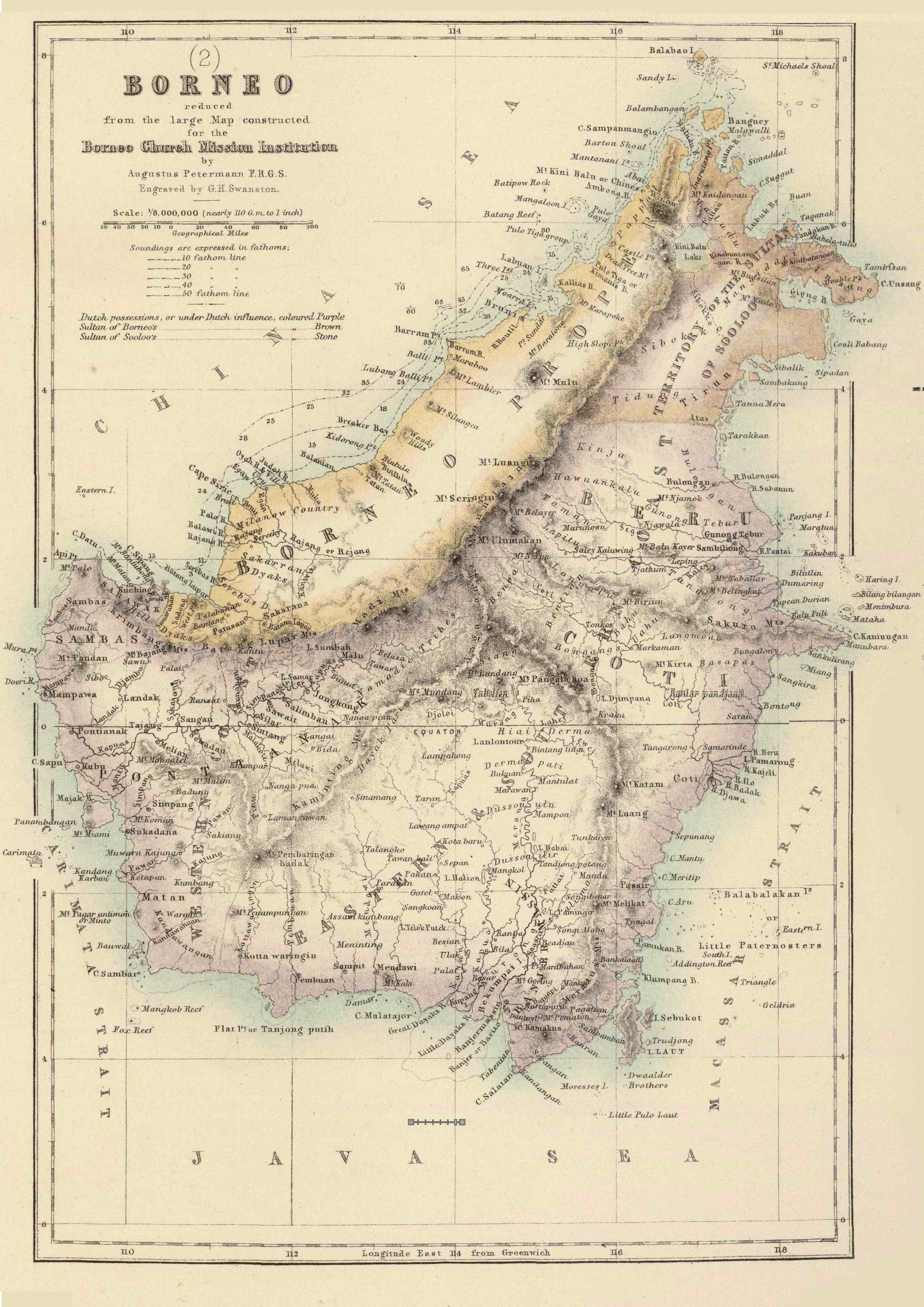
- Map of Borneo reduced from the large map constructed for the Borneo Church Mission Institute by by Augustus Petermann, F.R.G.S. and engraved by G.H. Swanston as part of the Principal Dutch colonies in the Indian seas ranging from 1822-1878 “Territory of the Sultan of Sooloo”.[18][19][20][21][22][23]
- 1876 map of Oriental Islands (Indonesia & Philippines, Borneo Celebes) by William Hughes, English geographer and cartographer, shows “Sooloo Territory”.[24][25]
- Map of Borneo En Celebes (translate from Dutch as: Borneo and Celeebes) from Wereld-atlas voor Kantoor en Huiskamer (translate from Dutch as: World Atlas for the office and living room), by Jacob Kuyper, a Dutch cartographer, published in 1880-1882 in Amsterdam, The Netherlands G. L. Funke shows “Soeloe Gebied” (translate from German as: Sulu Area) as located as east coast of Sabah and north of “Berausche Landen” (translate from German as: Berau Land)[26]
- Map of North Borneo by William Maunder Crocker, an administrator in Borneo, William John Turner, published in London by W. & A.K. Johnston Limited (by Scottish brothers, geographer and cartographer, Alexander Keith Johnston, and engraver and mapmaker, William Johnston) in 1881, which is after 1878 agreement, showing that in the smaller map on the bottom corner shows that part of what is now North Kalimantan, Indonesia (specifically Nunkan Regency, Tidung Regency, Tarakan and the northern tip of Malinau Regency) still being a “Territory of the Sultan of Sooloo”. At the main map, North Borneo is also writes “Territory ceded to the North Borneo Compy by the Sultan of Sulu”. This shows recognition by the British that the territory belonged to Sultanate of Sulu and before the agreement and not Brunei, and that the agreement was a cessation following the perspective of the British.[27] Note that just below the territory is Bulungan Regency where the Sultanate of Bulungan is located and is also thought to be part of the Sulu Sultanate up to 1880[28].
Note that there could be three different Borneo in some of the map: (i) Borneo island, often just referred to as ‘Borneo’, (ii) the country Brunei, often referred to as ‘Borneo Proper’ or also simply ‘Borneo’ or even a variation of the spelling ‘Brunei’ for later maps, and (iii) Borneo city, often referred to as ‘Bruni’ and its variation of spellings, or even ‘Borneo’.
 |
| A portion of the map of the East Indies published in 1855 by J. H. Colton & Co., an American cartographer, where the northeastern region of Sabah just north of Bulongan is shown as “Territory of the Sultan of Sooloo”[15][16][17]. The image here is directly from https://commons.wikimedia.org/wiki/File:1855_Colton_Map_of_the_East_Indies_%28Singapore,_Thailand,_Borneo,_Malaysia%29_-_Geographicus_-_EastIndies-colton-1855.jpg. It is available for purchase from geographicus.com/P/AntiqueMap/EastIndies-colton-1855. |
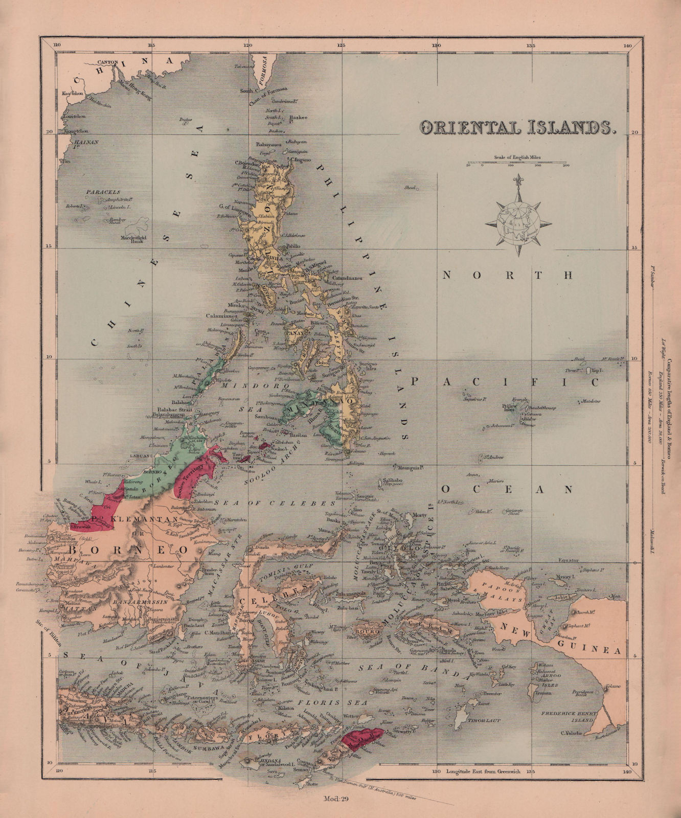 |
| 1876 map of Oriental Islands (Indonesia & Philippines, Borneo Celebes) by William Hughes, English geographer and cartographer, where the northeastern region of Sabah just north of Bulongan is shown as “Sooloo Territory”. The image here is directly from and can be purchased https://www.ebay.com/itm/164774584935[23]. It is also available for purchase at https://www.antiquemapsandprints.com/oriental-islands-indonesia--philippines-borneo-celebes-hughes-1876-old-map-465750-p.asp[24]. |
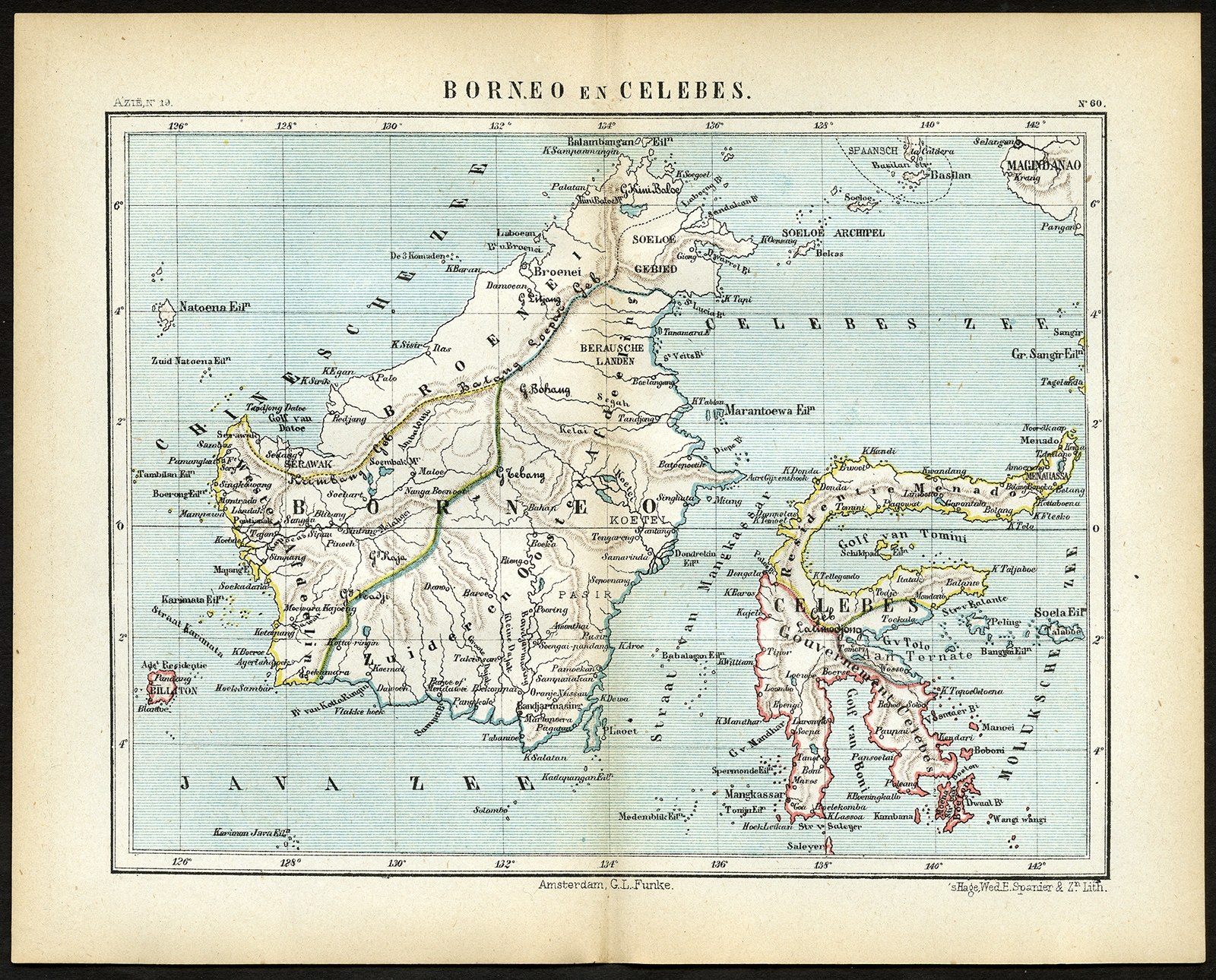 |
| Map of Borneo En Celebes (translate from Dutch as: Borneo and Celeebes) from Wereld-atlas voor Kantoor en Huiskamer (translate from Dutch as: World Atlas for the office and living room), Jacob Kuyper, a Dutch cartographer, published in 1880-1882 in Amsterdam, The Netherlands G. L. Funke shows “Soeloe Gebied” (translate from German as: Sulu Area) as located as east coast of Sabah and north of “Berausche Landen” (translate from German as: Berau Land)[25]. The image here is directly from and can be purchased at https://maps-prints.com/south-east-asia/2210-pl60-borneo-en-celebes-kuyper-1880.html[25]. |
 |
| Map of North Borneo (viewable at https://www.loc.gov/resource/g8033s.ct001928) by William Maunder Crocker, an administrator in Borneo, William John Turner, published in London by W. & A.K. Johnston Limited (by Scottish brothers, geographer and cartographer, Alexander Keith Johnston, and engraver and mapmaker, William Johnston) in 1881, which is after 1878 agreement, showing that in the smaller map on the bottom corner shows that part of what is now North Kalimantan, Indonesia (specifically Nunkan Regency, Tidung Regency, Tarakan and the northern tip of Malinau Regency) still being a “Territory of the Sultan of Sooloo”. At the main map, North Borneo is also writes “Territory ceded to the North Borneo Compy by the Sultan of Sulu”. This shows recognition by the British that the territory belonged to Sultanate of Sulu and before the agreement and not Brunei, and that the agreement was a cessation following the perspective of the British.[27] Note that just below the territory is Bulungan Regency where the Sultanate of Bulungan is located and is also thought to be part of the Sulu Sultanate up to 1880[28]. |
References
MLA Citattion:
- “The Sabah Treaties.” The Daily Brunei Resources, Blogger, 6 March 2013, bruneiresources.blogspot.com/2013/03/the-sulu-treaties.html. Accessed 15 April 2021
- Datu, Zad. “Transcript and Translation to 22 January Agreement Signed by Sultan Jamal-ul-Azam of Sulu appointing Baron de Overbeck.” Zad's Cavern of Random Works, Blogger, 16 May 2021, zadscavern.blogspot.com/2021/05/transcript-and-translation-to-22.html. Accessed 16 May 2021
- “Fellow Sabahans, in Conjunction with Upcoming North Borneo Self-Government Day on 31-Aug and Malaysia Day on 16-Sep, We Should Learn Our History...” Tell the Fake Sultan of Sulu That Sabah Belongs to the Sabahan People, Facebook, 23 August 2020, facebook.com/permalink.php?id=558845524139612&story_fbid=3581041015253366. Accessed 15 April 2021
- Black, I. The ending of Brunei Rule in Sabah 1878-1902. Journal of the Malaysian Branch of the Royal Asiatic Society, 41(2 (214)), 176-192, 1968, jstor.org/stable/41491952. Accessed 12 May 2021
- Low, Hugh. “The Sělěsîlah (Book of the Descent) of the Rajas of Bruni.” Journal of the Straits Branch of the Royal Asiatic Society, no. 5, June 1880, p. 17. eresources.nlb.gov.sg/printheritage/detail/c9633968-ba42-4fe9-a579-0bb2002fa2b0.aspx. Accessed 19 April 2021
- “Confirmation by Sultan of Sulu of Cession of certain Islands dated 22nd April 1903.” Jabatan Peguam Besar Negeri Sabah (Sabah State Attorney-General’s Chambers), 6 March 2013, sagc.sabah.gov.my/?q=en/content/confirmation-sultan-sulu-cession-certain-islands-dated-22nd-april-1903. Accessed 15 April 2021
- MENJ. “1903 ‘Confirmation of Cession of Certain Islands’ Agreement of the Sulu to the British North Borneo Company.” OTHER SIDE OF ME, Wordpress, 19 March 2013, ibnjuferi.me/1903-confirmation-cession-islands-agreement-sulu-british-north-borneo-company/. Accessed 15 April 2021
- “Sabah and the Sulu claims.” The Brunei Times, 7 March 2013, bt.com.bn/golden-legacy/2013/03/07/sabah-and-sulu-claims. Accessed 15 April 2021. Internet Archive. https://web.archive.org/web/20130921054404/http://www.bt.com.bn/golden-legacy/2013/03/07/sabah-and-sulu-claims. Archived 21 September 2013
- Origins of British Borneo (2nd ed.), by Leigh R. Wright, Hong Kong University Press, HKU, 1988, pp. 35. ISBN 9622092136 books.google.com.my/books?id=9SzxAQAAQBAJ&pg=PA35. Accessed 11 May 2021.
- “The North Borneo Cession Order in Council 1946”. Official Gazette. Government of the Philippines. 10 July 1946 – via gov.ph. This article incorporates text from this source, which is in the public domain. (effective as of 15 July 1946). officialgazette.gov.ph/1946/07/10/philippine-claim-to-north-borneo-vol-i-the-north-borneo-cession-order-in-council-1946/ Accessed 17 May 2021
- Severino, Rodolfo. “Where in the World is the Philippines?: Debating Its National Territory”. Institute of Southeast Asian Studies. pp. 40–. ISBN 978-981-4311-71-7, 2021. books.google.com/books?id=83BIxG7Ig2cC&pg=PA40 Accessed 17 May 2021
- Legends and History of Sarawak, by Pat Foh Chang, Kuching, Sarawak, Malaysia, 1999. ISBN 9789839475067 books.google.com.my/books/about/Legends_History_of_Sarawak.html. Accessed 12 May 2021
- Larsen, I. (2012). The First Sultan of Sarawak and His Links to Brunei and the Sambas Dynasty, 1599–1826: A Little-known Pre-Brooke History. Journal of the Malaysian Branch of the Royal Asiatic Society, 85(2 (303), 1-16. jstor.org/stable/24894189 Accessed 12 May 2021
- Petermann, Augustus ()1851, March 1). “Map of Borneo on constructed principally from that of Baron Melvill de Carnbee and the Unpublished Admiralty Surveys inscribed”. National Archives of Singapore, nas.gov.sg/archivesonline/maps_building_plans/record-details/336f9710-07c6-11e7-afb1-0050568939ad. Accessed 17 May 2021
- “East Endies” J. H. Colton & Co., 1855.
- Colton, G. W., Colton’s Atlas of the World Illustrating Physical and Political Geography, Vol 2, New York, 1855 (First Edition).
- “1855 Colton Map of the East Indies (Singapore, Thailand, Borneo, Malaysia).” Geographicus, geographicus.com/P/AntiqueMap/EastIndies-colton-1855. Accessed 25 September 2020
- “Some old maps of Borneo.” my North Borneo stamps, Blogger, 27 November 2014, mynorthborneostamps.blogspot.com/2014/11/some-old-maps-of-borneo.html, https://blogger.googleusercontent.com/img/b/R29vZ2xl/AVvXsEjxn1QNNfEZS6XzZJHriXZ7Y35ajeK1npDgf0sdCUHxs8QFCjFJihHHeZuA7CNVSO1TzZQ9FYlHHMX4ieLBqrO45qnCqmVsQS1a3J5Z2txqXdoOraLsYPdrvsdog1KD-HMttvgzGSlPpegK/s1600/Borneo+map+circa+1840.JPG. Accessed 23 July 2013
- Treasure House Books. “ORIGINAL 1856 MAP: Borneo by August Petermann”. AbeBooks.com, 19 February 2001, abebooks.com/servlet/BookDetailsPL?bi=30787797787. Accessed 17 May 2021
- “Archibald Fullarton: Borneo”. The Map House of London, themaphouse.com/search_getamap.aspx?id=137943&ref=SEAS4996. Accessed 17 May 2021
- “Principal Dutch Colonies in the Indian Seas. Fullarton, A. & Co. 1872”. David Rumsey Map Collection, davidrumsey.com/maps3086.html. Accessed 17 May 2021
- Quezon, Manuel L. III. “North Borneo (Sabah): An annotated timeline 1640s-present.” Sulu Online Library, 6 March 2013 https://suluonlinelibrary.wordpress.com/tag/history-of-sulu/page/19/. Accessed 12 May 2020
- Petermann, A. and Swanston, George H. and Thom, Alexander. and A. Fullarton & Co. Principal Dutch colonies in the Indian seas. Java according to Van de Velde [cartographic material] / drawn by Augustus Petermann, F.R.G.S. ; engraved by G.H. Swanston 1872 nla.gov.au/nla.obj-231269412. Accessed 17 May 2021
- “Oriental Islands. Indonesia & Philippines. Borneo Celebes. HUGHES 1876 old map”. Antiqua Print Gallery, antiquemapsandprints.com/oriental-islands-indonesia--philippines-borneo-celebes-hughes-1876-old-map-465750-p.asp. Accessed 17 May 2021
- jonart8. “1876 William Hughes map 'ORIENTAL ISLANDS' Borneo, Philippines, Java, New Guinea”. eBay, ebay.com/itm/164774584935. Accessed 17 May 2021
- Kuyper, Jacob. “Pl.60 Borneo en celebes - Kuyper (1880)”. Maps-Print.com, 1880, maps-prints.com/south-east-asia/2210-pl60-borneo-en-celebes-kuyper-1880.html. Accessed 17 May 2021
- Crocker, W. M, W. J Turner, and W. & A.K. Johnston Limited. Map of North Borneo. [London: W. & A.K. Johnston, 1881] Map. Retrieved from the Library of Congress, www.loc.gov/item/2007627503/ Accessed 29 May 2020
- Robert, Cribb. “Borneo in 1850”. Digital Atlas of Indonesian History, 2007 https://web.archive.org/web/20120610194305/http://www.indonesianhistory.info/map/borneo1850.html Accessed 17 May 2021
APA Citattion:
- The Sabah Treaties. (2013, March 6). The Daily Brunei Resources, Blogger. Retrieved 2012, April 15, from http://bruneiresources.blogspot.com/2013/03/the-sulu-treaties.html
- Datu, Zad. (2021, May 16). Transcript and Translation to 22 January Agreement Signed by Sultan Jamal-ul-Azam of Sulu appointing Baron de Overbeck. Zad's Cavern of Random Works, Blogger. Retrieved 2012, May 16, from https://zadscavern.blogspot.com/2021/05/transcript-and-translation-to-22.html
- Fellow Sabahans, in Conjunction with Upcoming North Borneo Self-Government Day on 31-Aug and Malaysia Day on 16-Sep, We Should Learn Our History.... Tell the Fake Sultan of Sulu That Sabah Belongs to the Sabahan People, Facebook. Retrieved 2012, April 15, from https://www.facebook.com/permalink.php?id=558845524139612&story_fbid=3581041015253366
- Black, I. D. (1968). “The Ending of Brunei Rule in Sabah 1878-1902.” Journal of the Malaysian Branch of the Royal Asiatic Society, vol. 41, no. 2 (214), 1968, pp. 176–192. JSTOR, Retrieved 2021, May 12, from https://www.jstor.org/stable/41491952.
- Low, Hugh. (1880, June). The Sělěsîlah (Book of the Descent) of the Rajas of Bruni. Journal of the Straits Branch of the Royal Asiatic Society, no. 5, p. 18, Retrieved 2021, April 19, from https://eresources.nlb.gov.sg/printheritage/detail/c9633968-ba42-4fe9-a579-0bb2002fa2b0.aspx
- Confirmation by Sultan of Sulu of Cession of certain Islands dated 22nd April 1903. (2013, March 6). Jabatan Peguam Besar Negeri Sabah (Sabah State Attorney-General’s Chambers). Retrieved 2012, April 15, from https://sagc.sabah.gov.my/?q=en/content/confirmation-sultan-sulu-cession-certain-islands-dated-22nd-april-1903
- MENJ. (2013, March 19). 1903 “Confirmation of Cession of Certain Islands” Agreement of the Sulu to the British North Borneo Company. OTHER SIDE OF ME. Retrieved 2012, April 15, from https://ibnjuferi.me/1903-confirmation-cession-islands-agreement-sulu-british-north-borneo-company/
- Sabah and the Sulu claims. (2013, Mar 7). The Brunei Times. Retrieved 2012, April 15, from https://web.archive.org/web/20130921054404/http://www.bt.com.bn/golden-legacy/2013/03/07/sabah-and-sulu-claims
- Wright, Leigh R. (1970). The Origins of British Borneo (2nd ed.). [Hong Kong, China]: Hong Kong University Press. pp. 35. ISBN 9622092136. Retrieved 2012, April 15, from https://books.google.com.my/books?id=9SzxAQAAQBAJ&pg=PA35
- The North Borneo Cession Order in Council 1946. Official Gazette. Government of the Philippines. 10 July 1946 – via gov.ph. This article incorporates text from this source, which is in the public domain. (effective as of 15 July 1946), Retrieved 2021, May 17 https://www.officialgazette.gov.ph/1946/07/10/philippine-claim-to-north-borneo-vol-i-the-north-borneo-cession-order-in-council-1946/
- Severino, Rodolfo (2011). Where in the World is the Philippines?: Debating Its National Territory. Institute of Southeast Asian Studies. pp. 40–. ISBN 978-981-4311-71-7, Retrieved 2021, May 17, from https://books.google.com/books?id=83BIxG7Ig2cC&pg=PA40
- Pat Foh Chang (1999). Legends and History of Sarawak. (2nd ed.). Kuching, Sarawak, Malaysia. ISBN 9789839475067. Retrieved 2021, May 12, from https://books.google.com.my/books?id=9SzxAQAAQBAJ&pg=PA35
- Larsen, Ib. “The First Sultan of Sarawak and His Links to Brunei and the Sambas Dynasty, 1599–1826: A Little-Known Pre-Brooke History.” Journal of the Malaysian Branch of the Royal Asiatic Society, vol. 85, no. 2 (303), 2012, pp. 1–16., www.jstor.org/stable/24894189. Accessed 12 May 2021.
- Petermann, Augustus. (1851, March 1). Map of Borneo on constructed principally from that of Baron Melvill de Carnbee and the Unpublished Admiralty Surveys inscribed. National Archives of Singapore, Retrieved 2021, May 17, from https://www.nas.gov.sg/archivesonline/maps_building_plans/record-details/336f9710-07c6-11e7-afb1-0050568939ad
- East Endies. (2013, March 6). J. H. Colton & Co.
- Colton, G. W. (1885). Colton’s Atlas of the World Illustrating Physical and Political Geography, Vol 2, New York (First Edition).
- 1855 Colton Map of the East Indies (Singapore, Thailand, Borneo, Malaysia). (2013, March6). Geographicus. Retrieved 2020, September 25, from https://www.geographicus.com/P/AntiqueMap/EastIndies-colton-1855
- Some old maps of Borneo. (2014, November 27) my North Borneo stamps, Blogger.Retrieved 2017, July 23, from https://mynorthborneostamps.blogspot.com/2014/11/some-old-maps-of-borneo.html, https://blogger.googleusercontent.com/img/b/R29vZ2xl/AVvXsEjxn1QNNfEZS6XzZJHriXZ7Y35ajeK1npDgf0sdCUHxs8QFCjFJihHHeZuA7CNVSO1TzZQ9FYlHHMX4ieLBqrO45qnCqmVsQS1a3J5Z2txqXdoOraLsYPdrvsdog1KD-HMttvgzGSlPpegK/s1600/Borneo+map+circa+1840.JPG
- Treasure House Books. (2001, February 19). ORIGINAL 1856 MAP: Borneo by August Petermann. AbeBooks.com. Retrieved 2021, May 17, from https://www.abebooks.com/servlet/BookDetailsPL?bi=30787797787
- Archibald Fullarton: Borneo. The Map House of London. Retrieved 2021, May 17, from https://themaphouse.com/search_getamap.aspx?id=137943&ref=SEAS4996
- Principal Dutch Colonies in the Indian Seas. Fullarton, A. & Co. 1872. David Rumsey Map Collection. Retrieved 2021, May 17, http://www.davidrumsey.com/maps3086.html
- Quezon, Manuel L. III. (2013, March 6). North Borneo (Sabah): An annotated timeline 1640s-present. Sulu Online Library. Retrieved 2020 May 12, from https://suluonlinelibrary.wordpress.com/tag/history-of-sulu/page/19/
- Petermann, A. & Swanston, George H. & Thom, Alexander. & A. Fullarton & Co. (1872). Principal Dutch colonies in the Indian seas. Retrieved 2021, May 17, from http://nla.gov.au/nla.obj-231269412
- Oriental Islands. Indonesia & Philippines. Borneo Celebes. HUGHES 1876 old map. Antiqua Print Gallery. Retrieved 2021, May 17, from https://www.antiquemapsandprints.com/oriental-islands-indonesia--philippines-borneo-celebes-hughes-1876-old-map-465750-p.asp
- jonart8. 1876 William Hughes map 'ORIENTAL ISLANDS' Borneo, Philippines, Java, New Guinea. eBay. Retrieved 2021, May 17, from https://www.ebay.com/itm/164774584935
- Kuyper, Jacob. (1880). Pl.60 Borneo en celebes - Kuyper (1880). Maps-Print.com. Retrieved 2021, May 17, from https://maps-prints.com/south-east-asia/2210-pl60-borneo-en-celebes-kuyper-1880.html
- Crocker, W. M., Turner, W. J. & W. & A.K. Johnston Limited. (1881) Map of North Borneo. [London: W. & A.K. Johnston] [Map] Retrieved from the Library of Congress. Retrieved 2020, May 29, from https://www.loc.gov/item/2007627503/.
- Robert, Cribb. (2007). Borneo in 1850. Digital Atlas of Indonesian History. Retrieved 2020, May 29, from https://web.archive.org/web/20120610194305/http://www.indonesianhistory.info/map/borneo1850.html
Comments
Post a Comment